Navigation for Mariners Around the Globe
Whether rounding the buoys or heading out to sail around the world every mariner needs the best navigation information available. Founded in 2013 while cruising Vanuatu, VentureFarther provides you with an integrated navigation platform found nowhere else. Crowd sourced anchorages with reviews, easy and fast satellite chart creation, global tides and weather, position reporting along with automatically updated and published "Cruiser's Guides". Jump in and take a look!
Satellite Charts
- The only 100% web based zero software install satellite chart service out there! Simply the fastest and easiest way to get satellite charts on any computer/tablet or phone.
- Both BSB/KAP and GeoTiff chart formats!
- Directly integrated with the iPad/Android and MacOS navigation app SEAiq.
- VFKaps Plugin for OpenCPN making it a simple button click to get your charts!
- Images from Google, Bing, Nokia and NOW Esri/ArcGIS!!
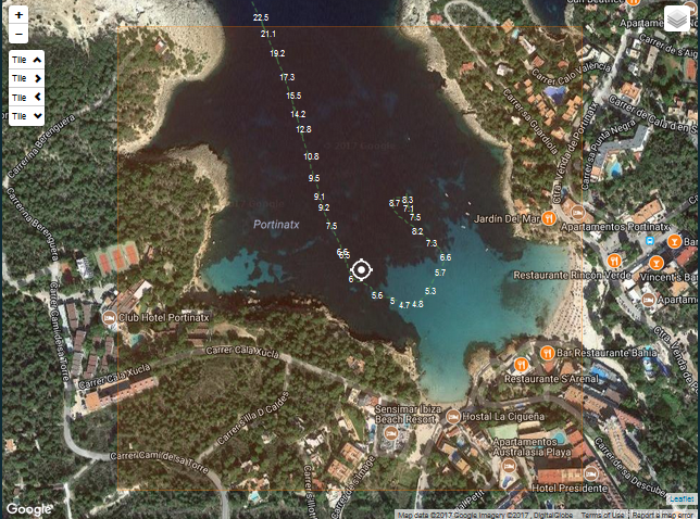
- Crowd source NMEA depth recording overlays! The only site that allows you to share depth recordings and have them immediately available as an overlay on a satellite chart.
Give it a try and create a Satellite Chart!

OpenCPN Plugin!
Awesome news for OpenCPN users. There is now a VFKaps OpenCPN plugin available! This is the fastest, easiest way to get Satellite Charts into OpenCPN. Move the chart to where you want a satellite chart, click the generate button, wait a few seconds and wham, you got it. Since this plugin requires no other software it works on both Windows and Linux.
Depth Sharing!
Marker, Route and Depth Recordings
- 2152 Shared Markers (and growing) from 100 different countries!
- Share information on anchorages, marinas and points of interest (and more) with mariners around the globe!
- Once you share a marker you are recognized both online and in the eBook for your contribution.
- Once 10 markers for a country are shared, the "Cruiser's Guide" eBook automatically publishes and is available for download. The only site in the world that offers this!
- Get the current tide and weather prediction for every shared anchorage.
- Upload NMEA recordings for sharing depths in poorly charted anchorages. Click Here to Learn How.
- Quickly earn VentureFarther credits by sharing cruising information, then download VentureFarther charts and eBooks for FREE.
Give the wizard a try and Share your favorite anchorage, fast and easy!
And make sure to check out the latest marker below. Thanks ANTHONY BODD!
Click Here to get the full details of this marker.
eBook Cruising Guides
With 1516 Cruising Guides downloaded so far! Once 10 markers for a country are shared a "Cruiser's Guide" is auto published from all the great crowd sourced information on VentureFarther. Each marker is attributed back to the VentureFarther member that shared the info. These books are in the open epub format and work well in iBooks(also Calibre and others). Click here to check out all of the available eBooks!
Travel Reports
- Create reports by email or online, you choose!
- Once created, any report can be either edited or deleted!
- Customizable, you select the basemap and routline colors.
- Upload Photos to your report (currently just online, email attachment coming soon).
- Member specific Travel Report page.
- Automatically email friends, family and cruising buddies when you submit a report.
- Invite Friends and Family easily with the VentureFarther Invite page, which will email the details on how they can sign up to track you. All in about 1 minute!
Click Here to get more information on how you can start up.
Latest Reports
The Members of VentureFarther
The 5409 mariners that chose to join and share information are what makes VentureFarther great. Without these people this cruising resource would not be what it is!
-
467 Markers
-
279 Markers
-
274 Markers
-
274 Markers
-
103 Markers
-
 2026-02-05 00:00:00.0
 -
 2026-02-04 00:00:00.0
 -
2026-02-03 00:00:00.0
-
 2026-01-31 00:00:00.0
 -
 2026-01-30 00:00:00.0
-
 2026-02-02 00:00:00.0
 -
2026-01-31 00:00:00.0
-
 2026-01-31 00:00:00.0
 -
 2026-01-29 00:00:00.0
 -
 2026-01-15 00:00:00.0
VentureFarther Credits
This site runs on a "VentureFarther Credit" system. By signing up (10 bonus credits for signing up, 5 more for adding a profile image) and sharing information you earn credits for things like Satellite Charts and eBooks. If you decide that you would rather not participate (or are using this site for commercial purposes) then there is the option for a low cost subscription. Click here for more information and to subscribe.
| FAQ | About Us | Contact | Terms Of Service | Privacy Policy |
